WESTCARB Carbon Atlas
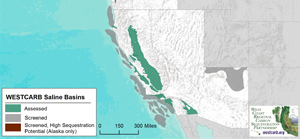
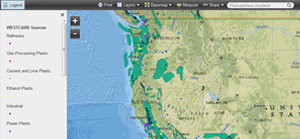
The WESTCARB Carbon Atlas provides the locations of major industrial CO2 emissions sources, areas with geologic formations capable of storing CO2, boundaries of publicly owned lands relevant to geologic and terrestrial sequestration opportunity characterization, and features such as transportation arteries, rivers and streams, and jurisdictional boundaries.
Available features
Data Access
Download WESTCARB data in a variety of formats including GIS files and ArcGIS web services