WESTCARB Carbon Atlas
The WESTCARB Carbon Atlas provides the locations of major industrial CO2 emissions sources, areas with geologic formations capable of storing CO2, boundaries of publicly owned lands relevant to geologic and terrestrial sequestration opportunity characterization, and features such as transportation arteries, rivers and streams, and jurisdictional boundaries.
Home > Map Gallery
The map gallery provides access to previously published maps of interest to the CCS community. Maps are updated when new data is integrated into the GIS database.
Saline Aquifers with Capacity


Saline Formations
Deep sedimentary basins are broadly distributed throughout the WESTCARB Region. Basins are screened (gray) for sequestration potential and assessed (blue) where sufficient information is available for a capacity estimate. In Alaska, basins with high sequestration potential (purple) are close to CO2 sources, infrastructure, and have ample characterization data. In the western coastal basins of Oregon and Washington, the total CO2 storage resource is in the range of 40-590 billion metric tons. In California, researchers estimate the aggregate CO2 storage resource of the largest onshore basins in the range of 30–420 billion metric tons. Actual storage capacity may be substantially lower due to the uniqueness of the geologic and working environments.
Sources:
Saline formation storage resource estimates are calculated according to the methodology developed by the Capacity and Fairways Subgroup of the Geologic Working Group of the DOE Regional Carbon Sequestration Partnerships. For details regarding this methodology, please refer to Appendix B of the 2010 Carbon Sequestration Atlas of the United States and Canada.
Downey, Cameron, John Clinkenbeard. (California Geological Survey) 2011. Studies Related to Geologic Carbon Sequestration Potential in California. California Energy Commission. Publication number: CEC-500-2011-044.
Myer, L., C. Downey, J. Clinkenbeard, S. Thomas, H. Zheng, H. Herzog, J.G. Price, R. H. Hess, S. Fitch, J. E. Faulds, L. J. Garside, L. Shevenell, S. Warren, S. Stevens, S. Benson, and B. Biediger. 2008. Preliminary Characterization of West Coast States for Geologic Carbon Sequestration. California Energy Commission, PIER Energy‐Related Environmental Research Program. CEC‐500‐2008‐019.
Shellenbaum, D.P., and Clough, J.G. 2010. Alaska Geologic Carbon Sequestration Potential Estimate: Screening Saline Basins and Refining Coal Estimates: California Energy Commission, Public Interest Energy Research Program.
Thomas, S.D. and P La Pointe, 2009, Storage Estimates – Washington and Oregon Onshore and Offshore Sedimentary Basins, Technical Memorandum, Golder Associates 063-1281.100.
Oil and Gas Fields with Capacity
Oil and Gas Reservoirs
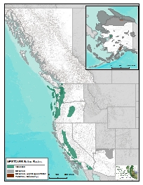
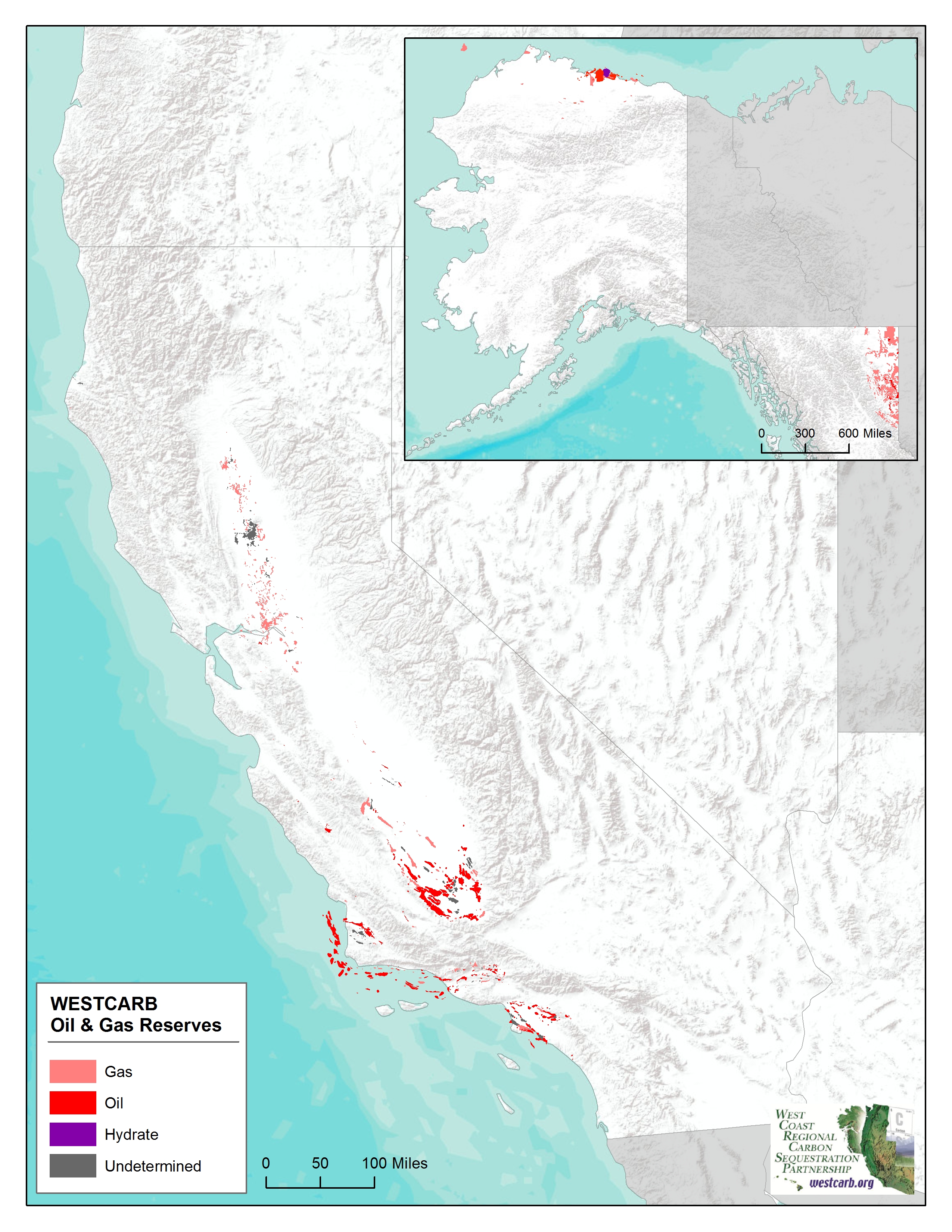
WESTCARB's oil (red) and gas (pink) fields, representing both CO2 storage targets and enhanced hydrocarbon recovery opportunities, are located mainly in Alaska and California. Major oil and gas producing regions are located within the Sacramento, Southern San Joaquin, Los Angeles, and Ventura basins and are capable of storing up to an estimated 5.2 billion metric tons of CO2. Many of these areas also have storage potential in saline aquifers. Offshore basins within conventional sandstone reservoirs add 240 million metric tons to the overall capacity.
In Alaska, the oil and gas fields on the North Slope are of prime interest because of the large potential for CO2 enhanced oil recovery (EOR), as well as their proximity to some of largest stationary sources of CO2 emissions in Alaska which are associated with oil and gas production. The hydrocarbon reservoirs of the Cook Inlet also offer potential for CO2 storage and EOR given their proximity to industrial CO2 sources.
Sources:
Oil and gas reservoir storage resource estimates are calculated according to the methodology developed by the Capacity and Fairways Subgroup of the Geologic Working Group of the DOE Regional Carbon Sequestration Partnerships. For details regarding this methodology, please refer to Appendix B of the 2010 Carbon Sequestration Atlas of the United States and Canada.
Thomas, S.D. and P La Pointe, 2009, Carbon Dioxide Resource Assessment –Oil and Gas Fields of California, Technical Memorandum, Golder Associates 063-1282.500.
Hwang, L.J., 2010, Corrections to Carbon Dioxide Resource Assessment –Oil and Gas Fields of California.
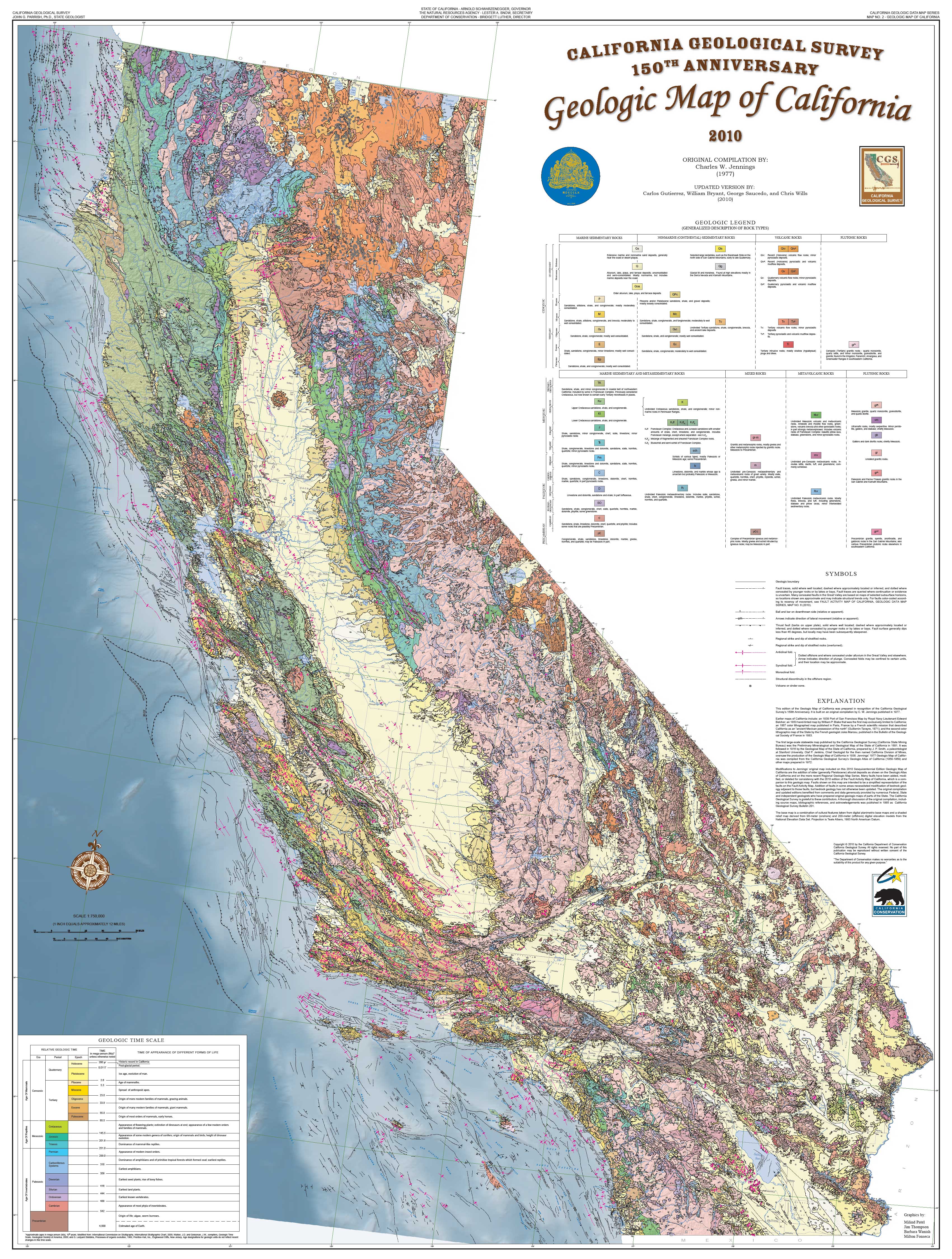
Coal Seams with Capacity
Unmineable Coal
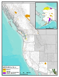
Opportunities for geologic CO2 storage in unmineable coal basins within the WESTCARB Region are found predominantly in the Pacific Northwest and Alaska. Screened coal areas (orange) have storage potential but volumes are not estimated due to insufficient data or pending future evaluations.
In the Pacific Northwest, three deep coal bed deposits offer promise: the Bellingham Basin in northwestern Washington; the coals of the upper Puget Sound Region, south and east of the Seattle-Tacoma metropolitan area; and small deposits in southwestern Oregon. In the Puget Sound (yellow), the estimated maximum CO2 storage potential is 1.3 billion metric tons and the estimated recoverable coal bed methane (CBM) is 57 to 570 billion m3. Coals interfingered with saline aquifers provide an opportunity for stacked storage in the Centralia region.
The highest potential coal seam CO2 storage opportunities in Alaska lie in unmineable coal beds in the North Slope and Cook Inlet regions (purple), which are relatively accessible and have coals of suitable thickness, depth, and permeability. Preliminary estimates of geologic CO2 storage resource in Alaska identify up to 24 gigatonnes of storage (yellow and purple).
Sources:
Unmineable coal area storage resource estimates are calculated according to the methodology developed by the Capacity and Fairways Subgroup of the Geologic Working Group of the DOE Regional Carbon Sequestration Partnerships. For details regarding this methodology, please refer to Appendix B of the 2010 Carbon Sequestration Atlas of the United States and Canada.
Bank, G. and S. Stevens, 2005. WESTCARB – Centralia Deep Coal CO2 Injection Potential Project. Meeting Poster.
Stevens, S., 2009, WESTCARB – Centralia Report
Shellenbaum, D.P., and Clough, J.G. 2010. Alaska Geologic Carbon Sequestration Potential Estimate: Screening Saline Basins and Refining Coal Estimates: California Energy Commission, Public Interest Energy Research Program.
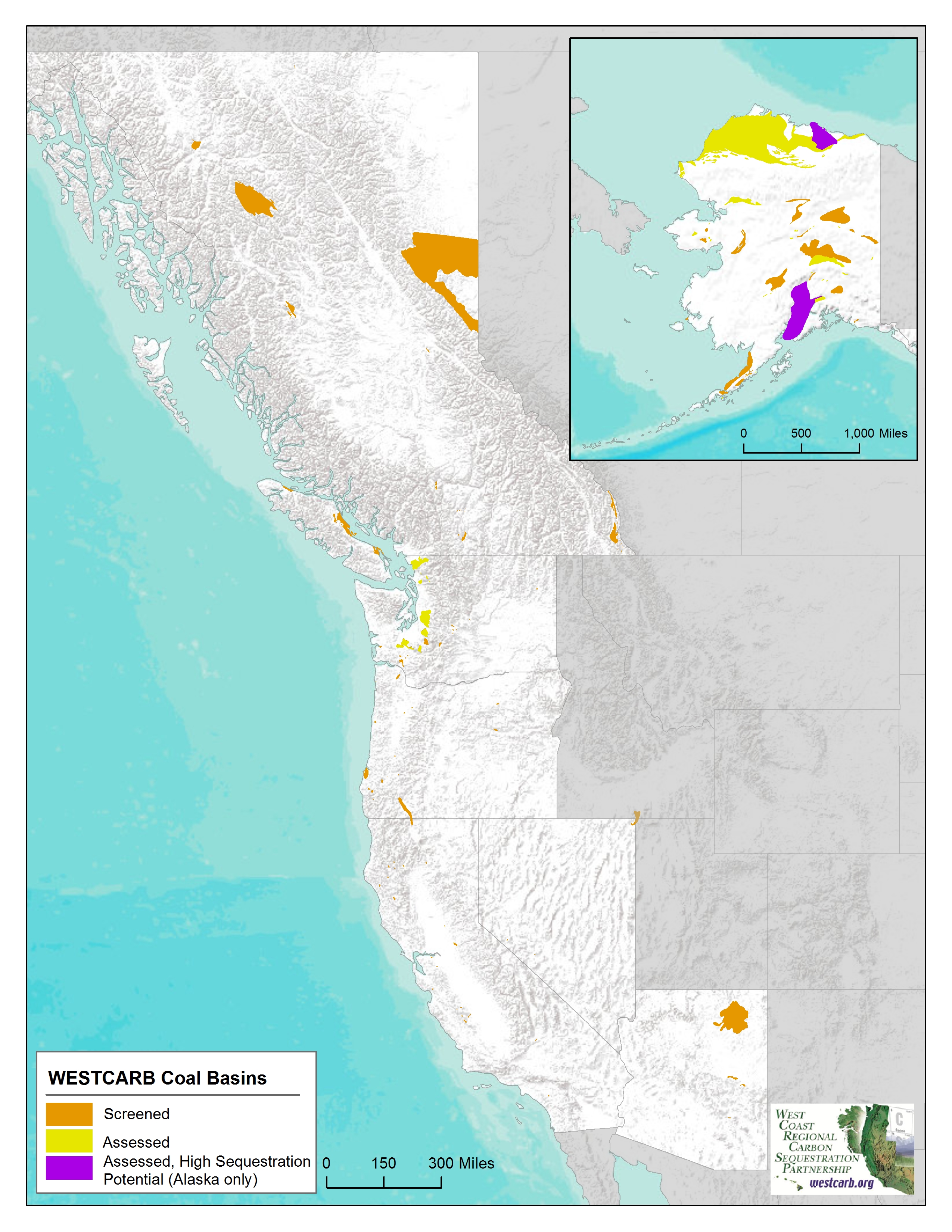
Emission Sources
CO2 Point Sources
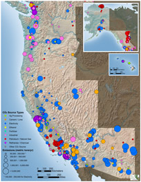
Electric power plants are the largest stationary CO2 source type in the WESTCARB region, although the fuel mix used for power generation varies among WESTCARB states. Arizona is home to the region’s largest coal-fired plants, whereas natural gas combined cycle plants are predominant in California and significant in several other states. Hawaii relies chiefly on oil-fired generation. Alaska is unique within the WESTCARB region in that oil and natural gas processing dominate CO2 emissions. Oil refining and chemical plants are also major emission sources in California.
Throughout the region, other significant industrial CO2 sources include cement and lime plants, aluminum smelters, pulp and paper mills, steel mills, ethanol fermenters, and fertilizer plants. Overall, the WESTCARB CO2 sources database includes information on more than 500 of the largest emitting point sources in the WESTCARB region.
Sources:
The point source emissions data in the WESTCARB Carbon Atlas were compiled from a number of sources, primarily EPA GHG reporting data for 2010 checked against eGRID 2010 (Year 2007) data. Environment Canada GHG data were used for British Columbia. The minimum emissions threshold for electricity is 100,000 metric tons CO2/year. For all other sources it is 50,000 metric tons CO2/year. Some locations have been adjusted using Google Maps latitude-longitude tool.
Status of Sedimentary Basins in California
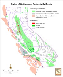
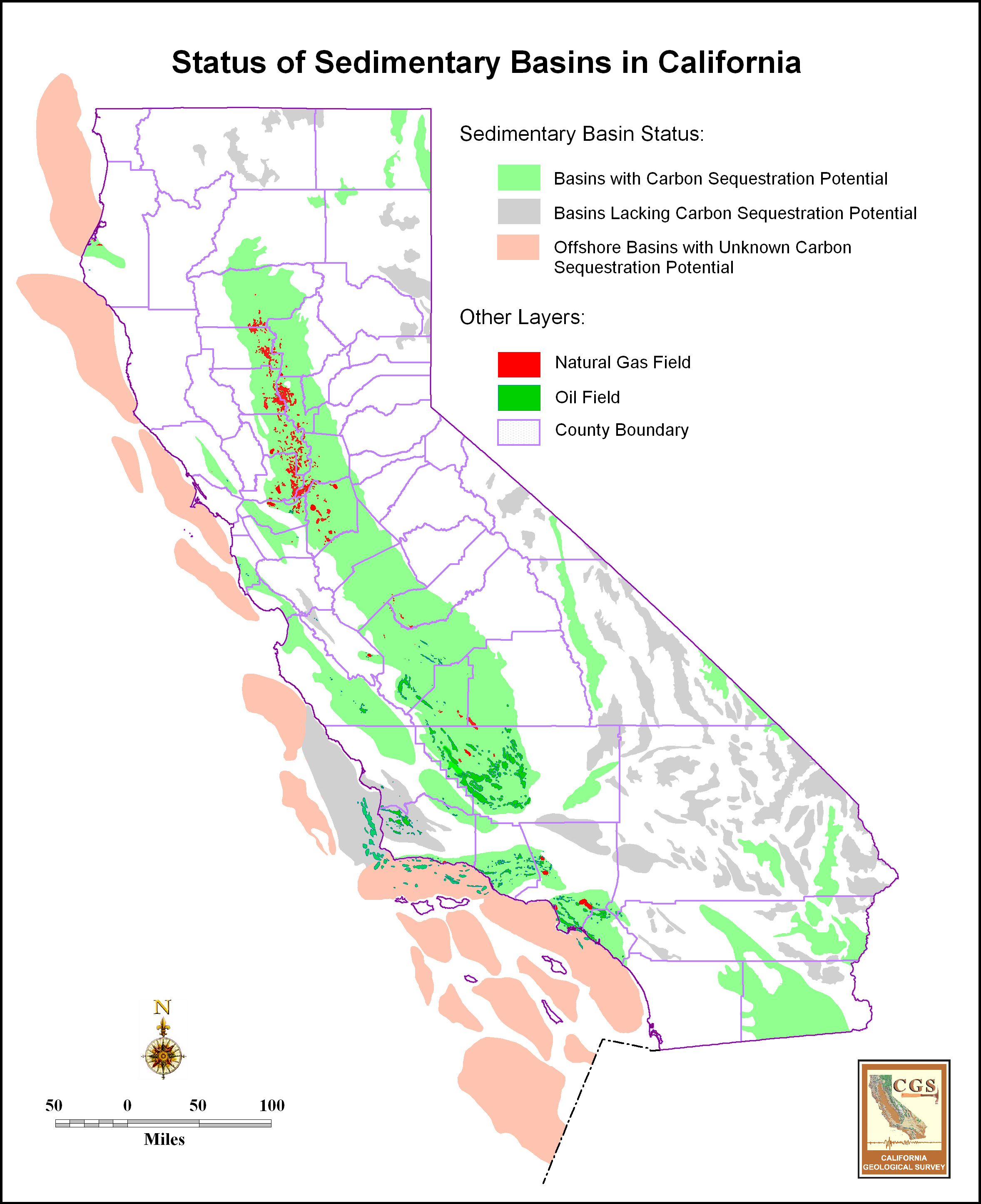
Status of Sedimentary Basins in California
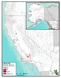
This map shows the current status of sequestration potential opportunities in California. Significant storage opportunities exist in California’s saline aquifers and in combination with oil and gas fields.
Sources:
Produced by the California Geological Survey for WESTCARB.
Downey, Cameron, John Clinkenbeard. (California Geological Survey) 2011. Studies Related to Geologic Carbon Sequestration Potential in California. California Energy Commission. Publication number: CEC-500-2011-044.
Hwang, L.J., 2010, Corrections to Carbon Dioxide Resource Assessment –Oil and Gas Fields of California.
Myer, L., C. Downey, J. Clinkenbeard, S. Thomas, H. Zheng, H. Herzog, J.G. Price, R. H. Hess, S. Fitch, J. E. Faulds, L. J. Garside, L. Shevenell, S. Warren, S. Stevens, S. Benson, and B. Biediger. 2008. Preliminary Characterization of West Coast States for Geologic Carbon Sequestration. California Energy Commission, PIER Energy‐Related Environmental Research Program. CEC‐500‐2008‐019.
Thomas, S.D. and P La Pointe, 2009, Carbon Dioxide Resource Assessment –Oil and Gas Fields of California, Technical Memorandum, Golder Associates 063-1282.500.
Status of Sedimentary Basins in California with point sources

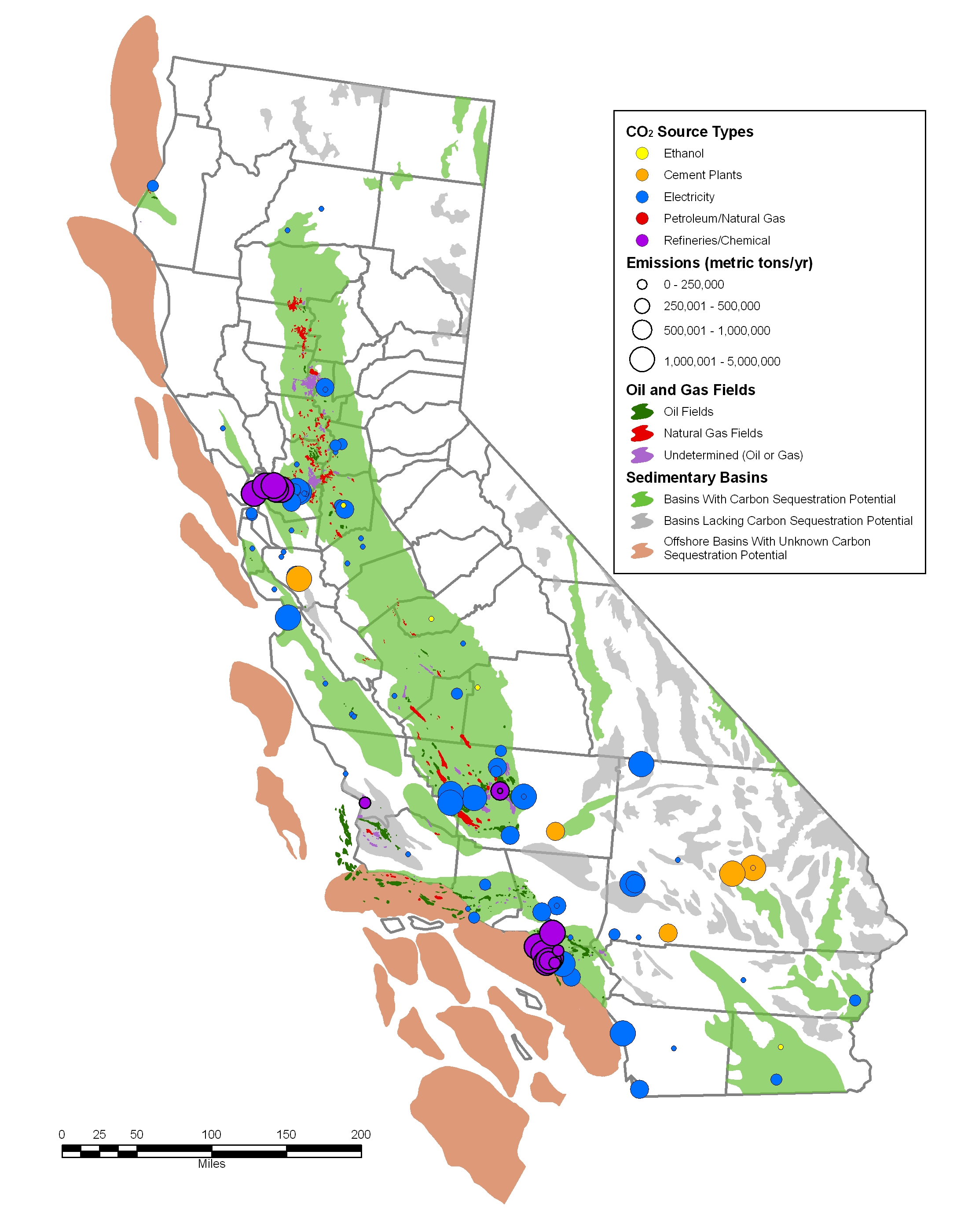
Status of Sedimentary Basins in California with point sources
This map shows the current status of sequestration potential in California, where significant storage opportunities exist in saline aquifers and in combination with oil and gas fields. Point sources of CO2, primarily power plants and refineries, are located near many of these resources.
Sources:
Produced by the California Geological Survey for WESTCARB.
Downey, Cameron, John Clinkenbeard. (California Geological Survey) 2011. Studies Related to Geologic Carbon Sequestration Potential in California. California Energy Commission. Publication number: CEC-500-2011-044.
Hwang, L.J., 2010, Corrections to Carbon Dioxide Resource Assessment –Oil and Gas Fields of California.
Myer, L., C. Downey, J. Clinkenbeard, S. Thomas, H. Zheng, H. Herzog, J.G. Price, R. H. Hess, S. Fitch, J. E. Faulds, L. J. Garside, L. Shevenell, S. Warren, S. Stevens, S. Benson, and B. Biediger. 2008. Preliminary Characterization of West Coast States for Geologic Carbon Sequestration. California Energy Commission, PIER Energy‐Related Environmental Research Program. CEC‐500‐2008‐019.
Thomas, S.D. and P La Pointe, 2009, Carbon Dioxide Resource Assessment –Oil and Gas Fields of California, Technical Memorandum, Golder Associates 063-1282.500.
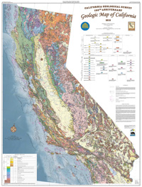
State Geologic Map: California
California Geological Survey - 2010 State Geologic Map of California
WESTCARB's pilot-scale terrestrial carbon storage projects mapped here tested measuring and monitoring practices to quantify the effectiveness of storage techniques, gathered information on project costs and benefits, and contributed to the development of forest carbon protocols. Projects in Shasta County, California, involved a dozen afforestation projects where native conifer and oak species were restored to rangelands and fire-damaged forest lands. Projects in both Shasta County and Lake County, Oregon, tested the effectiveness of hazardous fuels removal in reducing emissions. More information about WESTCARB's field projects can be found at http://www.westcarb.org/terresequestproject.html
Sources:
California Geological Survey:
http://www.consrv.ca.gov/cgs/cgs_history/Pages/2010_geologicmap.aspx
Coming Soon
Terrestrial Maps
Project Locations Geologic
Project Locations Terrestrial
State Geologic Map: California
Alaska Sequestration Potential for Saline Aquifers
Alaska Sequestration Potential for Coal Seams
Generalized Geologic Map: Alaska