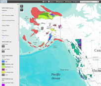
WESTCARB Carbon Atlas
The WESTCARB Carbon Atlas provides the locations of major industrial CO2 emissions sources, areas with geologic formations capable of storing CO2, boundaries of publicly owned lands relevant to geologic and terrestrial sequestration opportunity characterization, and features such as transportation arteries, rivers and streams, and jurisdictional boundaries.
Home > Data Explorer
The following web maps are available to view and interact with WESTCARB data sources in an online format
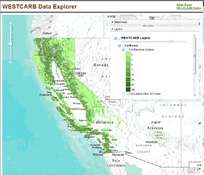
WESTCARB Data Explorer
The WESTCARB Data Explorer provides a web-based map platform to view and access information on WESTCARB data holdings for CO2 emission sources and CO2 sequestration potential in saline aquifers, oil and gas fields, and unmineable coal seams.
Use the menus along the top of the map to turn layers on and off, change the base map, access a measurement tool, and print or share your view by email, facebook, or twitter.
Each layer contains attribute information accessible by clicking on the feature in the map. An info bubble will display the information available for the selected feature. If there is more than one feature overlapping, a left and right arrow will appear at the top of the info bubble. Use these arrows to scroll through the overlapping features.
WESTCARB Terrestrial Data Viewer
The WESTCARB Terrestrial Data Explorer provides a web-based map platform to view and access information on terrestrial data holdings for carbon and conversion costs for a baseline time and after 20, 40, and 80 years.
Use the menu along the side of the map to turn different layers on and off, change the level of transparency, or change the base map.
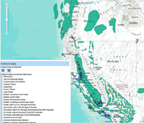
WESTCARB Data Extractor
The WESTCARB Data extractor allows you to export data from a specified map area.
Use one of the drawing tools to select an area of interest on the map. Next, s elect the layers to download. Then, choose a download format. Lastly, click the "extract data" button. The data will be clipped to the dimensions of the area designated, and added to a zip file for download.
Note that all of the selected layers will be saved as files. If no features exist in a selected area, the file will contain no data.
The data will be clipped to the extact dimensions of the area you have designated, and added to a zip file for download.
For attribute data, choose the "Shapefile" download option. Attribute data can be extracted from the .dbf file using excel.